

Published on Nov 30, 2023
Water is important to all life on earth; water is constantly formed newly through a phenomenon known as Hydrological cycle. An aquifer is an underground layer of water-bearing permeable rock, rock fractures or unconsolidated materials from which ground water can be extracted using water well. The study of water flow in aquifer and characterization of aquifer is called hydrology. The bed of low permeability along an aquifer is known as aquitard & aquiclude is a solid, impermeable area underlying or overlying an aquifer. Android platform is one of the area where an application can be utilized for mapping and collecting the details of bore well with geographical coordinates. Methodological approach based on GIS, Topographical maps are to be prepared using ArcGIS. Aquifer mapping is a multi-disciplinary holistic scientific approach for aquifer characterization, mapping of aquifers helps to determine the quantity of groundwater in a particular area, as a result prediction of ground water table is possible.
Keywords : GIS, Hydrology, Aquifer, Ground Water Table, ArcGIS, Android application
1. Developing an android app to collect the bore well data.
2. Collected data using mobile app in southern part of Chikkaballapura.
3. Converted mobile data to GIS compactable format.
4. Generation of Grid map.
5. Extraction of depth contours using Grid map.
6. Sub surface zonation mapping of Aquifer.
7. Preparation of Thiessen polygon map.
8. Prediction of Aquifer zones & Ground water depth for new bore well.
9. To avoid the risk from unused bore wells, which is kept open without casing by giving suitable information to decision makers.
10. Development of the ground water by using suitable rainwater harvesting methods.
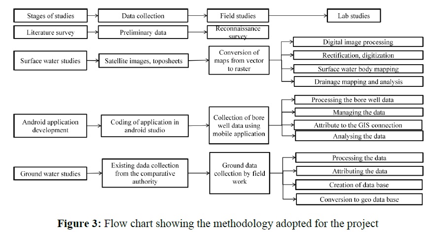
1. Using android studio, android application is developed to collect the bore well data.
2. Data collection and field studies are done together in the villages of southern part of Chikkaballapura.
3. Surface water studies are done using Satellite images and toposheets.
4. Ground water studies are done by analysing the collected bore well data by Thiessen polygon & Depth contours extraction.
5. Mapping of Aquifer zones & Ground water depth prediction for new bore well.
6. Suggestion of suitable rain water harvesting methods to improve the ground water condition.
7. Analysing the problem for depletion of ground water table.
8. Examples of Maps shown in figure 1 & 2.

1. In a selected village, bore well data were collected through the mobile application.
2. From 10 villages 464 bore well data’s were collected.
3. In 464 bore well data, 295 yielding bore well, 132 bore wells are not yielding, and 36 failure bore wells are present.
4. It is identified that 45 open wells were kept open and dangerous, and after our advices 2 people covered there open well with fencing.
5. Bore well which are more than 800-1000 ft. depth, they are yielding till today.
1. Ground water is depleting day by day in the villages of southern part of Chikkaballapura.
2. Mapping monitoring is the biggest problem in rural areas.
3. Subsurface mapping will give the idea about aquifer.
4. Exhausted bore well are not closed and they are leaving dangerous.
5. Ground water is the major source of irrigation in the study area.
6. Suggestion of rain water harvesting methods for the farmers in the selected villages.
7. Android app is the one of the area where it can be utilized for monitoring and collecting the details with geographical coordinates.
8. Subsurface mapping of existing bore well data helps in finding the depth of ground water availability for new bore well.
1. This mobile application can be used in future for aquifer mapping in large area.
2. It is also useful for the prediction of ground water potential zones in future.
3. It can be utilised for the prediction of the depth of new bore well.
4. Made assessable to the competent authority for prediction, mapping analysis & decision making in future ground water studies
1. Basavaraj D. B., C. G. Hiremath, J. Davithuraj, B. K. Purandara, “Identification of groundwater potential zones using ArcGIS 10.1.”. Journal of Hydrology, Volume 1, pp. 34-35, 2016.
2. S. Buchanan, J. Triantafilis, “Mapping water table depth using geophysical and environmental variable by Inverse Distance Weighting and Ordinary Kriging.”, Volume 1, pp. 154, 2008.
3. Kiplangat Cherono Nelly , Felix Mutual, “Ground water quality assessment using GIS and remote sensing: a case study of Juja location, Kenya.”, Journal of Hydrology, Volume 2, pp. 69, 2016.
4. Ramu, Mahalingam. B, Vinay. M “Identification of ground water potential zones using GIS and remote sensing techniques”: a case study of Mysore taluk –Karnataka, pp. 54-79, 2014.
