

Published on Nov 30, 2023
Globally the availability of fresh water is a limited resource and needs sustainable management of this resource. Given the varied bio-climatic zones, rainfall patterns vary and each geographic area receives a certain mean annual rainfall. However, in certain areas with changing water demand, there is a perceived sense of inadequate rainfall over the years and hence overall yield resulting of this precipitation.
One such case is applicable for the upstream catchment of River Shimsha that originates in Tumakuru district of Karnataka. With changing agriculture practices and increase in population, water demand has increased that has often pushed for the need to draw water from other watersheds. Consequently, Tumakuru district is fed with water drawn from River Hemavathy through human-made channels.
Further with uneven and uncertain rainfall events, there is a perceived sense of inadequate rainfall calling for declaring the region as ‘drought’ prone despite a decent mean annual rainfall in the catchment. In this backdrop it becomes pertinent to assess the potential yield of runoff from rainfall in the catchment. This can be achieved by delineating the watershed and analysing the stream network in the watershed for possible yield using appropriate methods.
Geographical Information System (GIS) is an effective tool to perform many operations such as digitization, delineation of streams of a watershed and carry out a variety of spatial analysis. This tool can be efficiently used to carry out hydrological analysis and hence used for sustainable watershed management projects.
A few studies in the recent past have attempted to study the water resource management in Hassan district using GIS (NungshichilaLongchar et al., 2014). Similarly, morphometric analysis combined with GIS has been applied for studying watersheds in Kunigal area of Tumarkuru district (AbhishekBothra et al., 2014) and Tungabhadra drainage basin in Karnataka (Ramu et al., 2013).
Thus, this study aims to delineate the River Shimsha watershed and estimate the potential discharge from runoff in the catchment using GIS.
Keywords : River Shimsha; Delineation; GIS; Morphometry; Strange’s table; yield of runoff; discharge of river; rainfall runoff analysis;
A. To delineate the watershed of River Shimsha using toposheet and Satellite based DEM
B. To evaluate and compare the drainage network of River Shimsha derived from toposheet and DEM through spatial and morphometric analysis
C. To estimate the discharge from River Shimsha using hydrological methods and spatial analysis
In order to achieve above mentioned objectives, the following data will be gathered:
i. Toposheet for the study area from Survey of India
ii. ASTER DEM from USGS Global Data Explorer, NASA Earth Data.
iii. Rainfall data from 1901-2015 from Directorate of Economics and Statistics, Government of Karnataka
iv. Geospatial data from public domain like OpenStreetMap
v. Relevant statistical data from Census of India and District Irrigation Departments.
vi. Strange’s table to estimate the yield of runoff of watershed based on mean annual rainfall.
The geospatial data will be processed and analysed using QGIS, a free and open source geospatial software (http://qgis.org/). The rainfall and other statistical data will be analysed using available spreadsheet package like MS Excel.
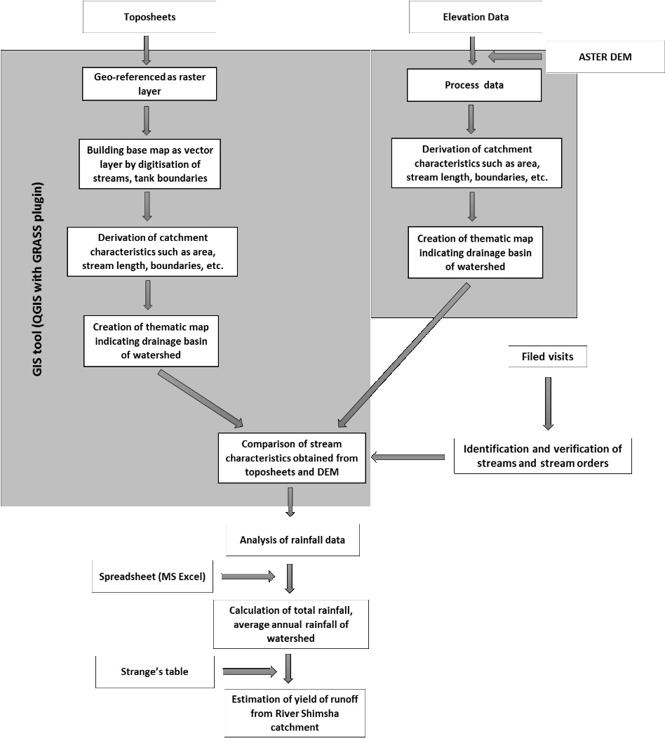
The methods that was followed to delineate watershed of RiverShimsha is depicted in Figure 1. To start with, toposheets from Survey of India for the study area (at a scale of 1:50000) were collected. With the help of GIS tool (QGIS), these were geo-referenced as raster layers and the digitization of dendritic drainage pattern was carried out. For stream ordering, StrahlerHorton’s law was followed by designating an un-branched stream as first order stream, when two first order streams joined it was designated as second order. Two second order steams join together to form third order and so on. The number of streams of each order were counted and recorded. The drainage map along with basin boundaries were digitized as a line coverage giving unique id for each order of stream.
Subsequently, the elevation data in the form of digital elevation model from ASTER was downloaded and processed in the GIS tool (QGIS with GRASS plugin). Mainly three layers constituting stream segments, micro watershed basins and accumulation of the basin were derived based on the elevation of the terrain. This was analysed to derive the catchment characteristics. A thematic map was generated indicating the drainage basin of the watershed.
Morphometric parameters under linear and shape were computed using standard methods and formulae (Horton 1932, 1945; Smith 1954; Strahler, 1964).The fundamental parameter namely; stream length, area, perimeter, number of streams and basin length were derived from drainage layer. Verification of these were carried for a select sample of streams derived from the above methods through field visits which aided in assessing the current status of some of the streams in reality and data derived from the above method.
In the next phase, rainfall data were collected and analysed using a spreadsheet package (MS Excel). The total rainfall and average annual rainfall of watershed were calculated. Strange’s table – a method for rainfall-runoff computation was used to estimate the potential yield of runoff from the Shimsha River catchment.
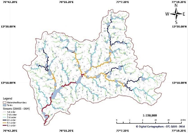
1. The watershed of River Shimsha has been delineated and a thematic map indicating watershed boundary, stream network and tanks has been developed based on both toposheet and DEM methods.
2. The derived thematic map are visually similar and morphometric parameters are comparable and does not have gross errors.
3. The mean annual average rainfall of the watershed is found to be 666 mm
4. The theoretical yield of runoff from the catchment is found to bea minimum of 3.3 TMC (93522 million litres) and an average of 4.94 TMC (139854 million litres). The estimates of minimum and average yield are based on Strange’s table classification of average and bad catchments respectively.
Based on the current study, a theoretical estimate of the yield of runoff suggests a significant volume of water in the catchment. In order to properly utilize the available natural water resource a detailed investigative study has to be conducted and the streams have to be restored in order to accumulate the estimated quantity of water.
The present work carried out can aid for further studies on the Shimsha watershed and help planning for a sustainable water resource management.There is scope for detailed studies on the following which might assist for water resource management of Tumakuru district.
Cause for interruptions in the stream network and status of the tanks in the watershed.
A detailed estimation of cost for rejuvenation of streams of various order.
A detailed study with land use and land cover remote sensing data to investigate the changes in usage of land and action for recovery of streams.
The study has revealed that a minimum of about 3.3 TMC or an average of 4.94 TMC of water can be accumulated annually out of the Shimsha drainage basin which is a significant quantity of water. This study has been carried out on theoretical basis considering topographical data (streams) from toposheets and remote sensing satellite based digital elevation model. The results obtained from both the methods are very similar when compared with each other.
Further, based on field visits it was found that inflows for a majority of lower order streams like 1stand 2ndorder streams are affected and disturbed thus affecting the inflows for higher order streams. This is contributing to lesser inflows eventually.Since the current work aimed at estimating the overall yield of runoff from catchment, it did not attempt to estimate this for all micro-watersheds in the catchment. However, it has been observed that the following are affecting the inflows to the stream and catchment in general:
1. Changing cultivation pattern from dry land farming to water intensive cash crops resulting in higher water demand.
2. As a consequence, most runoff in the farmlands are often retained without being let to existing streams affecting inflows to tanks and higher order streams eventually.
3. Change of land-use from natural and/or agriculture to others (like built-up).
