

Published on Nov 30, 2023
Contamination of freshwater bodies caused by saltwater intrusion is a global issue, affecting water quality, vegetation, and soil conditions along coastal lines. Any developmental activity will largely depend upon availability of fresh water to meet domestic, industrial and agricultural demands therefore water resources in coastal areas assume a special significance. Excessive pumping of groundwater reverses the natural hydraulic gradient and aquifer may become saline. Karwar is a progressively converting in to an urban area. As a result of rapid urbanization the demand of water is increasing day by day. Because of this reason the groundwater extraction has increased leading to have their own source of water by digging or boring a well. The poor supply of water has encouraged people to withdraw groundwater. Due to change in the land use pattern, the natural rainfall and recharge of groundwater has also decrease to the certain extent.
Karwar is located in the west coast of India in the Uttar Kannada district of Karnataka. Coastline of Karwar extends to a distance of about 30km. The study area, Karwar coast and seven islands covering an area of 270 sq.km is situated in the Arabian sea between 14°45’-14°55’N Lat. And 74°-74°07’30”E Long.
The focus of this research is on applying the GALDIT model to access saltwater intrusion vulnerability in regions of Karwar. The most important factors controlling saltwater intrusion are groundwater occurrence (aquifer type; unconfined, confined, and leaky confined), aquifer hydraulic conductivity, depth to groundwater level above the sea, distance from the shore, impact of existing status of saltwater intrusion, and thickness of the aquifer. The three significant parts of this system are weights, ranges, and ratings. Each GALDIT factor has been evaluated with respect to the other to determine the relative importance of each factor.
Keywords : Aquifer, GALDIT model, Groundwater, Seawater intrusion.
Sea water intrusion problem in the northern Karnataka has not yet reached the serious magnitude but, if the present situation remains identical for the next few years then, this may leads to the alarming situation. Thus, for the present study Karwar and some adjoining areas of Karwar are selected to understand the present scenario of the sea water intrusion. This project is aimed to meet the following objectives.
1. Simulation of sea water intrusion using GALDIT model in the Karwar costal region.
2. To understand the change in the water table and the water potential zone.
3. Preparation of the various thematic maps for the representation of the problem, using GIS platform.
Preliminary survey was done with the help of Geospatial Environmental Model using R (GEM-R) software grid was plotted for one kilometer distance and center of the grid is considered as the point where sampling has to be carried out. This center points as layer converted to the .kml file and imported on way point finder application available at Google play store application of android. With the help of this location points are located. At some points it was not possible to collect the sample exactly at point, in such cases sampling well at marks in a radius of 100mts from the center point. On this basis we have selected about 43 sampling locations, where water samples were collected and brought to the laboratory the subjected to the chemical analysis. During the sampling total depth of the well, static depth of the well and thickness of the water column is measured to understand the change in the water table.
For GALDIT model numerical ranking system has been devised using the factors to assess sea water intrusion extent. The system contains three significant parts: weights, ranges and ratings. Groundwater samples were collected in 45 days interval January, March, and May 2016. Based upon the bi-monthly measurements of salinity, groundwater quality in all the observation wells was found to be reasonably fresh in pre-monsoon periods.
Change in the water level is directly related to the change in the water table from the coastal aquifer. This change is an open invitation for the sea water intrusion in the study area. Change in the water table is mainly due to the over exploitation of water, less input of the fresh water and evaporation of the water. But evaporation plays a minor role in this regard.
Total depth of the well will provide the general information about the depth of the aquifer in the study area which is of more importance in understanding of distribution of the water table in the study area. While the static depth and water column depth will help in understanding of change in the water level. Water level change has generally observed in the month of May where water level in the study area reduced to the extreme level.
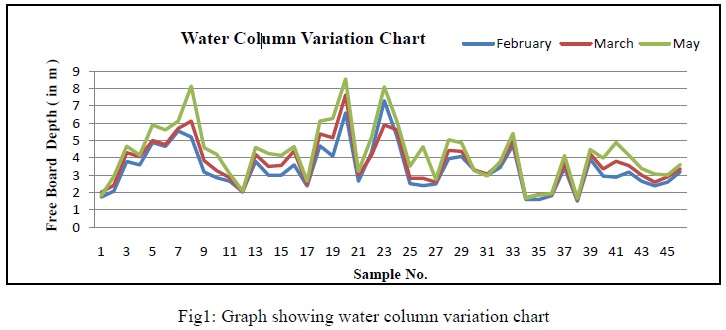
With the help of collected data various maps are prepared to understand about the water level variations in the study area. Figure1 shows the depth variations using the last three samplings. From this it has been found that, at maximum wells water levels are decreasing as we go towards the summer season this may be due to the over exploration of the fresh water from the open well and may be also due to the less or no input of fresh water to the aquifer.
It has been observed that on an average the depth of water level changes for about 0.5 to 1 meter in three months. And if this continues then the water level will go down to the very minimum range the sea water will intrude to the costal fresh water aquifer. This may cause a permanent damage to the coastal aquifer.
Groundwater quality parameters such as Cl, CO3 and HCO3 etc. are measured for all samples of three months. Using these data thematic maps are prepared in a raster calculation option to understand about the areas that are affected by the sea water intrusion. From these figures it has been observed that northern part of the study area is under more threat to the sea water intrusion than the southern portion this may be due to the presence of high elevations towards the southern portion of the study area.
According to GLADIT index, if the index value exceeds 7.5 then the area is under high risk to sea water intrusion. If the values range from 7.5 to 5 then area is under moderate risk to sea water intrusion and if the values are below 5 then area is safe from sea water intrusion.
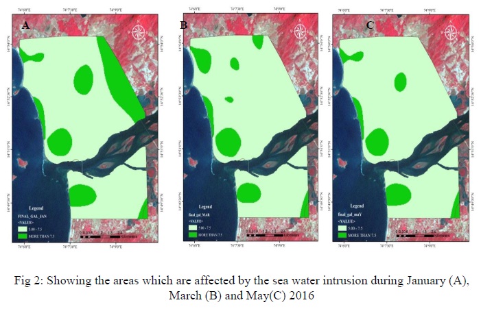
Thus from the above three figures it is clear that the southern part of the study area is safe from the sea water intrusion and northern part of the study area is under moderate risk to sea water intrusion.
The experiments and sample collection is done for the shorter period and that also only for the pre-moonsoon season. In future post-moonsoon sampling can be done to understand the seasonal variations in the study area.
The city of Karwar is on beach ridges and lineaments. It is reported that the beach ridges are slowly vanishing along the coast especially at Karwar and Majali, owing to urbanization and other developmental activities (Hanamgond and Mitra, 2007). Rocky islands are present near the coast indicating submergent as well as emergent coast. So to understand underground conditions the resistivity survey has to be carried out to know in detail the different zone below the ground. In future water samples can be collected near to the lineaments to understand the intrusion of sea water if any.
During first sampling the average values for the vulnerability index are 7.02 which show that effect of sea water intrusion is moderate in the area. Highest values are observed towards the northern areas. In case of second sampling, an average value is 7 and for third sampling average value is 6.94. It has been observed from the above images that the vulnerability to sea water intrusion depends upon the climatic conditions especially depends upon the addition of fresh water by means of rainfall. During the month of March area has experienced the rainfall for shorter duration and thus the values of vulnerability have declined during second sampling.
From the sample testing it has been found that most of the GALDIT VALUE INDEX are between 5 to 7.5 indicating that those areas are under moderate risk to sea water incursion but some of the area (up to 1 km extent from the sea coast) have GALDIT INDEX VALUES more than 7.5 which indicates that those areas are under high risk to sea water incursion.
In the month of January and March the effect of sea water intrusion is more compare to May because the canal water was released into the river during May. This may be one of the reasons for the decrease in the effect of sea water intrusion during May. Due to the early arrival of summer this season, the amount of ground water used in Karwar was more, which also is one of the major reason why the risk of sea water intrusion is higher in the month of January and March.
