
Published on Nov 30, 2023
In the increased need for transportation on land and commutation for various professional, personal and emergency needs, the need for a better civil infrastructure for transportation like roads and railways; holds its well defined place in the budgetary of any nation. Modern data acquisition and analysis mechanisms have changed the ways the design and planning of transport infrastructure is conducted. Further, there are many software tools that simulate the traffic and structure behavior well before the actual design is freezed. With all these in hand, we find issues with respect survey of dynamically changing traffic conditions, planning fly-over, crawl-under, metro railroads and so on. In this project we have tried to resolve the issue by using the existing data acquisition techniques and intend to develop a comprehensive tool that not only collects the data but also analyses, recommends certain plan, provides design templates for the recommended plan, considering all the natural parameters like the soil conditions, weather conditions and also obligatory points
Keywords: — Google API, Open CV, Phantom JS, Google Compute Engine.
Intelligent Transportation Systems (ITS) is the application of computer, electronics, and communication technologies and management strategies in an integrated manner to provide traveler information to increase the safety and efficiency of the surface transportation systems. These systems involve vehicles, drivers, passengers, road operators, and managers all interacting with each other and the environment, and linking with the complex infrastructure systems to improve the safety and capacity of road systems. As reported by Commission for Global Road Safety(June 2006) , the global road deaths were between 750,000 to 880,000 in the year 1999 and estimated about 1.25 million deaths per year and the toll is increasing further. World health organization report (1999), showed that in the year 1990 road accidents as a cause of death or disability were the ninth most significant cause of death or disability and predicted that by 2020 this will move to sixth place. Without significant changes to the road transport systems these dreadful figures are likely to increase significantly.
1. In Bangalore on an average scale an individual spends 1500 hours per year on the road stuck in traffic congestion.
2. Considering the cost of 100 Rupees per hour, with the population of just Bangalore the cost to the state would be approximately 6500 cores.
3. Further, due to the increased density of traffic on roads, accidents, breakdowns and other random events also increase.
4. These incidents further increase the congestion on road of a typical city.
5. In order to manage the increasing demands placed on the surface transportation system, Intelligent Transportation Systems(ITS) are being deployed.
6. To improve the efficiency, safety, and predictability of travel.
7. Many intelligent transportation systems (ITS) for their success depend on the availability of timely and accurate estimates of prevailing and emerging traffic conditions.
8. This necessitates a traffic prediction system that uses advanced traffic models to analyze data, especially real-time traffic data, from different sources.
9. The estimates and predictions derived from such a system can be used to select proactive strategies for meeting various traffic control, management, and operation objectives.
10. We intend to develop a comprehensive tool that can improve traffic conditions and reduce travel delays by facilitating better utilization of available capacity
11. i.e., by estimating and predicting the traffic density accurately, where people can take alternative routes to balance the utilization of the available capacity.
1. The tool being developed has two main functions:
i. Traffic Estimation
ii. Traffic prediction
2. Estimation provides the information about the current state of the traffic.
3. Prediction is the interpolated information of the estimated current conditions which represents the expected future traffic.
4. Methodology includes the continuous online evaluation of the traffic layer provided by google maps i.e, by taking snapshots of a junction and its adjacent stations which adds to the inflow and outflow of traffic of the junction under evaluation from different directions with periodic intervals.
5. The snapshots obtained have different colours representing the traffic densities
6. Red representing heavy traffic condition, yellow representing moderate traffic condition and green represents low traffic condition.
7. These colours in the snapshots are quantized for the calculation.
8. This quantized value gives the current state of the traffic.
9. Further the values obtained are plotted against the time.
10. Equation can be derived from the graph plotted which can be used for the future traffic predictions.
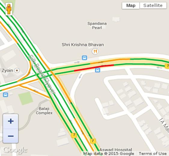
This is the sample taken at silkboard junction.Which represent various traffic densities.

The White colour in the image corresponds to the red colour of the sample snapshot which represents the Heavy traffic density.

The White colour in the image corresponds to the yellow colour of the silkboard junction snapshot which represents the moderate traffic density.

The White colour in the image corresponds to the green colour of the sample snapshot which represents the low traffic density.
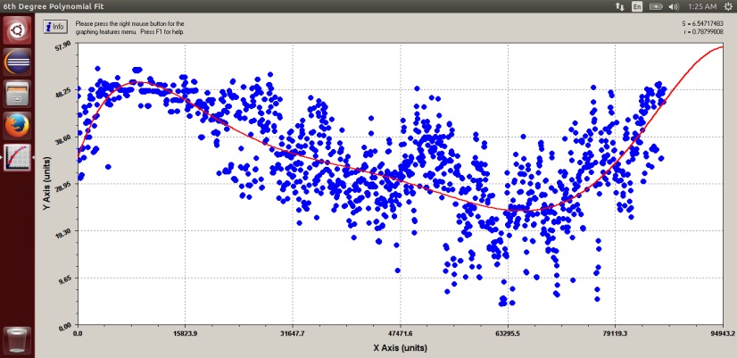
This is a graph obtained when quantitative data of the low traffic density respresented by the colour green is plotted against the time at which the snapshot was taken.
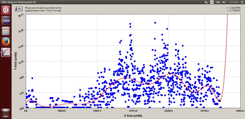
This is a graph obtained when quantitative data of the heavy traffic density represented by the colour red is plotted against the time at which the snapshot was taken.
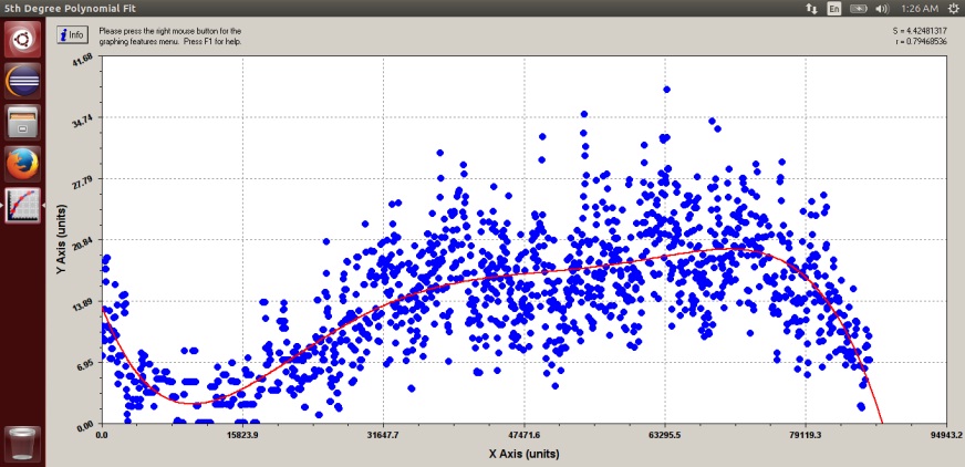
This is a graph obtained when quantitative data of the moderate traffic density represented by the colour yellow is plotted against the time at which the snapshot was taken.
1. The transportation planning plays a crucial role in solving traffic problems.
2. Transportation planning software is a leap in the development of transportation infrastructure. The transportation planning software comes to a new stage when the GIS, Remote sensing, simulation of traffic and other similar technologies are used.
3. The transportation planning software is hardly an indispensable tool for transportation planners. There is hardly any transportation planning project which does not use transportation planning software today.
4. In the rapidly growing cities like Bangalore a major hurdle to plan is the survey data. The density of traffic, the environmental conditions, soil conditions, and so on.
5. Further, calculating the deviation ratio with high precision of the traffic from an existing clogged road into newly constructed roads would take its own sweet time for the survey engineers.
6. Our predictor can forecast the traffic demand with the current traffic conditions, which can be further used to plan, and design infrastructural designs considering all the parameters and at hand and dynamically change the designs as per requirement in matter of minutes. This will not only facilitate the engineers with the survey but also will provide templates for design scientifically.
Our project mainly concentrates on traffic monitoring and tends to provide suitable infrastructural solutions which helps in increasing country’s economy and decrease the time wasted due to congestion.
1. M A Chowdhary and A Sadek. Fundamentals of Intelligent Transportation systems planning. Artech House Inc., US, 2003.
2. Bob Williams. Intelligent transportation systems standards. Artech House, London, 2008.
