

Published on Nov 07, 2018
The Sardar Sarovar Project is one of the largest water resources project of India covering four major states - Maharashtra, Madhya Pradesh, Gujarat and Rajasthan. Dam's spillway discharging capacity (30.7 lakhs cusecs) would be third highest in the world.
With 1133 cumecs (40000 cusecs) capacity at the head regulator, and 532 km. length, the Narmada Main Canal would be the largest irrigation canal in the world.
The dam will be the third highest concrete dam (163 meters) in India, the first two being Bhakra (226 metres) in Himachal Pradesh and Lakhwar (192 meters) in Uttar Pradesh. In terms of the volume of concrete involved for gravity dams, this dam will be ranking as the second largest in the world with an aggregate volume of 6.82 million cu.m. The first is Grand Coule Dam in USA with a total volume of 8.0 million cu.m. This dam with its spillway discharging capacity of 85,000 cumecs (30 lakh cusec), will be the third in the world, Gazenba (1.13 lac cumecs) in China and Tucurri (1.0 lac cumecs) in Brazil being the first two.
The reservoir would occupy an area of 37,000 ha. and would have a linear stretch of 214 kilometer of water and an average width of 1.77 kilometer. The Full Reservoir Level (FRL) of the Sardar Sarovar Dam is fixed at RL 138.68 metres (455 feet). The Maximum Water Level is 140.21 metres (460 feet.) while minimum draw down level is 110.64 metres (363 feet.). The normal tail water level is 25.91 metres (85 feet.).
The plan for harnessing the river for irrigation and power generation in the Narmada basin was initiated in 1946. Seven projects including the Bharuch project were identified during the initial Survey and 4 projects Bharuch (Gujarat), Bargi, Tawa and Punasa in Madhya Pradesh were given top priority for investigation. After the completion of investigation, the proposed dam at Gora in Gujarat with the full reservoir level (FRL) 161 ft (49.08m) was selected and the foundation stone was laid by late Prime Minister, Pandit Jawaharlal Nehru on 5th April, 1961. However as more detailed, modernised contour sheets from the Survey of India were available thereafter, possibility of raising the height of the dam for optimum utilisation of water was considered.
In 1964, to resolve the dispute about sharing of the Narmada Waters between the Governments of Gujarat and Madhya Pradesh, the Government of India appointed an expert committee under the Chairmanship of late Dr. Khosla which recommended a higher dam with FRL 500 ft (152.44m) in 1965. However, Govt. of M.P. was not agreeable to development of Narmada water as per Khosla Committee report and hence the Narmada Water Dispute Tribunal (NWDT) was constituted by the Government of India in October 1969, under the Inter State River Water Disputes Act, 1956. NWDT gave its final award in December 1979.
The Sardar Sarovar Project will provide irrigation facilities to 18.45 lac ha. of land, covering 3112 villages of 73 talukas in 15 districts of Gujarat. It will also irrigate 2,46,000 ha. of land in the strategic desert districts of Barmer and Jallore in Rajasthan and 37,500 ha. in the tribal hilly tract of Maharashtra through lift. About 75% of the command area in Gujarat is drought prone while entire command in Rajasthan is drought prone. Assured water supply will soon make this area drought proof.
A special allocation of 0.86 MAF of water has been made to provide drinking water to 131 urban centres and 9633 villages (53% of total 18144 villages of Gujarat) within and out-side command in Gujarat for present population of 28 million and prospective population of over 40 million by the year 2021. All the villages and urban centres of arid region of Saurashtra and Kachchh and all "no source" villages and the villages affected by salinity and fluoride in North Gujarat will be benefited. Water supply requirement of several industries will also be met from the project giving a boost to all-round production
There are two power houses viz. River Bed Power House and Canal Head Power House with an installed capacity of 1200 MW and 250 MW respectively. The power would be shared by three states - Madhya Pradesh - 57%, Maharashtra - 27% and Gujarat 16%. This will provide a useful peaking power to western grid of the country which has very limited hydel power production at present. A series of micro hydel power stations are also planned on the branch canals where convenient falls are available.
It will also provide flood protection to riverine reaches measuring 30,000 ha. covering 210 villages and Bharuch city and a population of 4.0 lac in Gujarat.
Wild life sanctuaries viz. "Shoolpaneshewar wild life sanctuary" on left Bank, Wild Ass Sanctuary in little Rann of Kachchh, Black Buck National Park at Velavadar, Great Indian Bustard Sanctuary in Kachchh, Nal Sarovar Bird Sanctuary and Alia Bet at the mouth of River will be benefited.
SSP would generate electricity. On completion, annual additional agricultural production would be Rs. 1600 crores, power generation and water supply Rs. 175 crores, aggregating about Rs. 2175 crores every year equivalent to about Rs. 6.0 crores a day.
The Full Reservoir Level (FRL) of the Sardar Sarovar Dam is fixed at RL 138.68 meters (455 feet). The Maximum Water Level is 140.21 meters (460 feet.) while minimum draw down level is 110.64 metres (363 feet.). The normal tail water level is 25.91 meters (85 feet.).
The gross storage capacity of the reservoir is 0.95 M. ha.m. (7.7 MAF) while live storage capacity is 0.58 M.ha.m. (4.75 MAF). The dead storage capacity below minimum draw down level is 0.37 M. ha. m. (2.97 MAF). The reservoir would occupy an area of 37,000 ha. and would have a linear stretch of 214 kilometer of water and an average width of 1.77 kilometer.
The submergence at Full Reservoir Level (FRL) is 37,533 ha. (86,088 acres), which comprises 11,279 ha. agricultural land, 13385 ha. forest land and112869 ha. river bed and waste land. In all 230 villages of the three states viz. 178 Villages of Madhya Pradesh, 33 villages of Maharashtra and 19 villages of Gujarat are affected. Only 3 villages of Gujarat are fully affected, while the remaining 16 villages are partly affected. As on 31.03.2018, 4763 PAFs from Gujarat, 5549 PAFs from Madhya Pradesh and 750 PAFs from Maharashtra has been resettled in 236 R&R colonies in Gujarat.
A concrete gravity dam, 1210 meters (3970 feet) in length and with a maximum height of 163 meters above the deepest foundation level, is completed and it has been dedicated to Nation at the worthy hands of Hon’be Prime Minister on 17.09.2017.
The dam is the third highest concrete dam (163 meters) in India, the first two being Bhakra (226 metres) in Himachal Pradesh and Lakhwar (192 meters) in Uttar Pradesh. In terms of the volume of concrete involved for gravity dams, this dam is ranking as the second largest in the world with an aggregate volume of 6.82 million cu.m. The first is Grand Coule Dam in USA with a total volume of 8.0 million cu.m. This dam with its spillway discharging capacity of 85,000 cumecs (30.00 lac cusecs), is the third in the world, Gazenba (1.13 lac cumecs) in China and Tucurri (1.0 lac cumecs) in Brazil being the first two.
For chute spillway Radial gates, 7 in number and size 60' x 60' and for service spillway, 23 Radial gates of size 60' x 55' are provided to negotiate the design flood. 10 number of temporary construction sluices, each of size 2.15 m x 2.75 m. are provided in the boby of the spillway at RL 18 m. Another set of 4 permanent river sluices are provided at RL 53.0 m. The lower sluices were closed in February, 1994.
The design of the dam allows for a horizontal seismic coefficient of 0.125g and it also covers an additional risk due to reservoir induced seism city. Most sophisticated seismological instruments for monitoring and evaluation of the stresses in the body of the dam as well as the effect on the periphery of the reservoir are under installation.
There are two power houses for the Sardar Sarovar Project (SSP). Power benefits are shared among Madhya Pradesh, Maharashtra and Gujarat in the ratio of 57:27:16 respectively.
The RBPH is an under ground power house stationed on the right bank of the river located about 165 meters downstream of the dam. It has six number of Francis type reversible turbine generators each of 200 MW installed capacity. The T.G. Sets are supplied by M/S Sumitomo Corporation, Japan and M/S BHEL. These units can operate at minimum reservoir water level of 110.64 meters. These six units have been commissioned in a phase manner during Feb-05 to June-06. The generation of energy depends upon inflow of water from upstream projects and need of water for irrigation in Gujarat.
The CHPH is a surface power station in a saddle dam on right bank of the reservoir having total installed capacity of 250 MW (5 x 50 MW). These five units have been commissioned in a phased manner during Aug-04 to Dec-04. These units can be operated with minimum reservoir water level of 110.18 meters.
The CHPH is being operated in consultation and as per advice of NCA/WREB based on irrigation requirement of Gujarat/Rajasthan and availability of water in reservoir and release from upstream project of Madhya Pradesh.
The energy generated from both the power houses is to be evacuated through 400 KV level through interconnecting transformers at GIS, situated in RBPH switch yard. The 400 KV Switchyard is indoor type having Gas Insulated Switch Gear and Bus bars. The energy is transmitted to party states i.e. Gujarat, Maharashtra and Madhya Pradesh in the proportion of 16:27:57 respectively through 400 KV double circuit transmission lines, namely SSP-Kasor, SSP-Asoj, SSP-Dhule and SSP-Nagda respectively. All the transmission lines are commissioned and charged.
The operation and maintenance of SSP power complex is being done by Gujarat State Electricity Company Limited (GSECL), for which O&M agreement between SSNNL and GSECL has been signed.
Development of Small Hydro Power Projects at Canal falls at various Branch Canals is in progress under EPC mode of implementation for the captive use of power at pumping stations of SSNNL.
SSNNL has successfully commissioned 10 MW Canal Top Solar Photovoltaic Grid Connected Power Plant on Vadodara Branch Canal in November-2014. It was dedicated to the Nation by H.E. Mr. Ban Ki-moon, United Nations Secretary-General on 11th January, 2015.
Also, 10MW Solar Power Projects on Canal Top & 15MW Canal Bank Power Projects at Vadodara Branch Canal have been successfully commissioned in October-2017 for the captive use of power at pumping stations of SSNNL.
In order to provide water in the regions of Saurashtra & Kachchh of Gujarat, SSNNL has constructed the Pumping Stations on Saurashtra Branch Canal & Kachchh Branch Canal for lifting of Narmada Canal water.
Narmada Main Canal is a contour canal. It is the biggest lined irrigation canal in the world. It is about 458.318 km. long up to Gujarat -Rajasthan border. The canal extends further in the state of Rajasthan to irrigate areas in Barmer and Jhalore districts of Rajasthan. The Main Canal is lined with plain cement concrete to minimise seepage losses to attain higher velocity and to control the water logging in future. The lining work is carried out with the mechanized pavers. Such a large scale paving of concrete lining is done for the first time in India.
The Main Canal in its journey has to negotiate several water streams, rivers, roads, railways etc. This is possible by constructing appropriate structure on the canal. In all, there are 638 structures on the Narmada Main Canal. Narmada Main Canal as on today is completed up to 458 Km. and water has been flowing throught it right upto the state of Rajasthan.
1. Full supply level (F.S.L.) at H.R. 91.44 m (300 ft)
2. Length up to Gujarat - Rajasthan border 458.318 Km
3. Base width in head reach 73.10 m
4. Full supply depth (F.S.D.) in head reach 7.60 m
5. Design discharge capacity
1. In head reach 1133 cusecs(40,000 cusecs)
2. At Gujarat Rajasthan border 74.55 cusecs (2,600 cusecs)
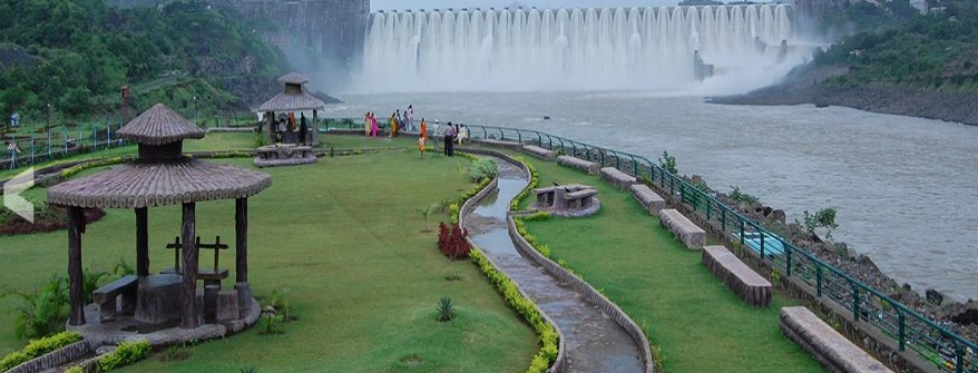
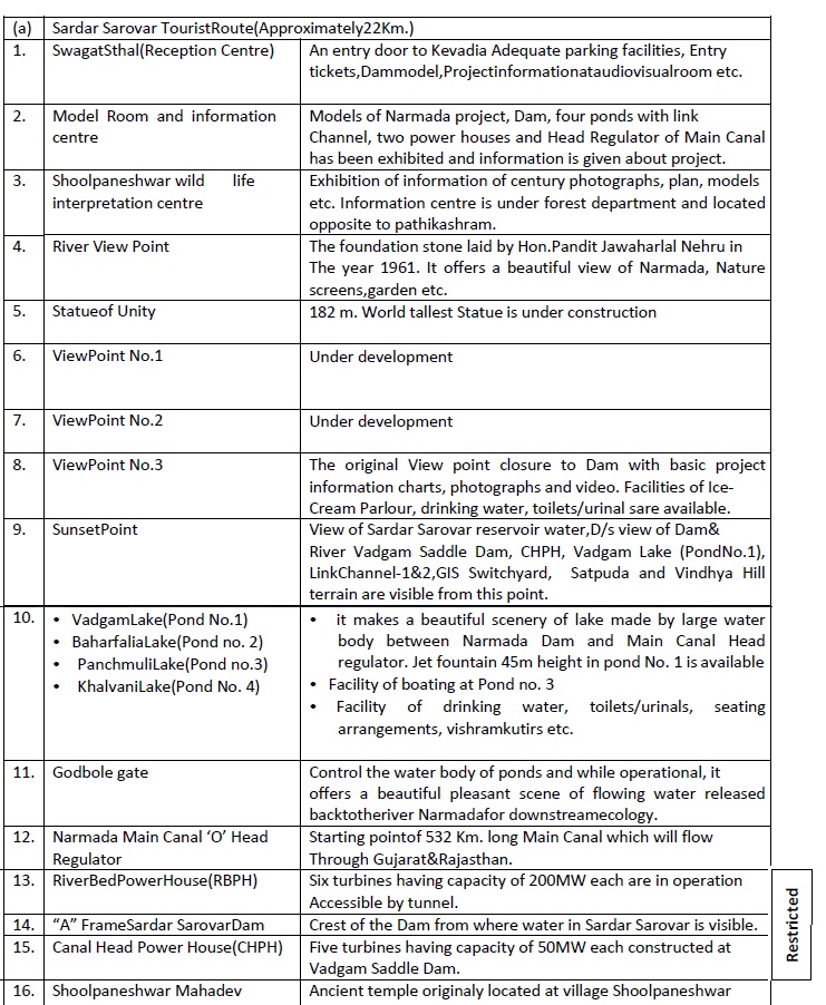
a) Sardar Sarovar Tourist Route (Approximately 22Km.)
• Narmada Darshan Model Room
• Shoolpaneshwar wild life interpretation centre
• Documentary of SSP at Audio Visual Room in Reception centre
• Statue of Unity(Under Construction)
• View points No.3
• Sun set Point
• Dykes & Lakes
God bole Gate
• Narmada Main Canal “O” Head Regulator
River Bed Power House (RBPH)
“A” Frame Sardar Sarovar Dam
Canal Head Power House(CHPH)
b) Religious Places
• Shoolpaneshwar Templeat Gora
• Datt Mandir at Garudeshwar
• Harisiddhi Mataji Temple at Rajpipla
• Mataji temple at Dev Mogra
• Bhadarva Dev Tample at Bhadarva
c) Eco Tourism Sites
• Zarwani Water Fall
• Eco‐Tourism Centre at Vora‐Vajiria
• Eco‐Tourism Centre at Vishal Khadi
• Ninai Waterfall
• MalSamot
d) Educational Tourism
• Dam and Power House
• Canal Structures
In the history of human endeavor to intervene and harness the natural resources for its welfare, Sardar Sarovar Project emerges as one of the very few projects across the globe that have played a significant role in bettering the quality of life for millions. With its unique features and unparallel dimensions, SSP has undoubtedly occupied a remarkable position on the world atlas of water resources development. Apart from its manifold benefits in terms of long term water, energy and food security and thereby sustainable development of Gujarat State, SSP has overcome many engineering and technological challenges during its journey from concept to its present stage. In true sense, it is the Engineering Marvel. TIME magazine, in 1994 described the Narmada Project as one of the “Eight Modern Wonders Abuilding”. Such a recognition brings to the Project that glory which the Tajmahal enjoys in the field of ancient structures.
One of the most studied water resources projects of the world, SSP has successfully adopted path-breaking approaches for arriving at the technological solutions at every step of its implementation. It has been a forerunner in terms of offering new dimensions and evolving fresh engineering standards – be it planning, designing or implementation. Engineering issues dealt with in the different project components like dam, hydropower, canal, canal structures and so on, had no off the shelf solutions existing anywhere in the world. “Necessity is the mother of invention” – this has been absolutely true in the case of SSP and has led to many distinctive elucidation.
From the view point of integrated development with basin approach, SSP is a part of much larger plan of utilization of the whole course of river Narmada – the Fifth largest in the country, comprising 30 Major Dams, 135 Medium Dams and about 3,000 Minor Dams along the 1,312 km length.
