Cyclone Alert for Odisha, Andhra Pradesh: Cyclonic Storm over the Bay of Bengal
Deep Depression over Northwest & adjoining west-central Bay of Bengal: Cyclone Alert for north Andhra Pradesh and adjoining south Odisha coasts – Yellow Message
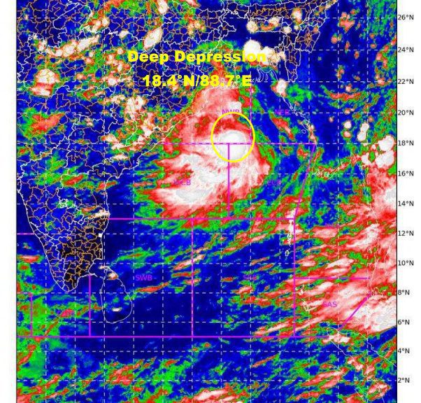
The Deep Depression over northwest & adjoining westcentral Bay of Bengal moved westwards with a speed of 17 kmph in last 6 hours and lay centered at 1130 hrs IST of 25 th September 2021, over northwest and adjoining westcentral Bay of Bengal near Lat. 18.4°N and Long. 88.7°E, about 410 km east-southeast of Gopalpur (Odisha) & 480 km east-northeast of Kalingapatnam (Andhra Pradesh).
It is likely to intensify into a Cyclonic Storm during next 06 hours. It is likely to move nearly westwards and cross north Andhra Pradesh – south Odisha coasts between Kalingapatnam & Gopalpur by evening of 26th September, 2021.
Warnings:
(i) Rainfall
25th Sept.:
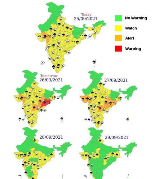
Light to moderate rainfall at many places with heavy rainfall at isolated places likely over Gangetic West Bengal, Odisha and Coastal Andhra Pradesh.
26th Sept.:
Light to moderate rainfall at most places with heavy to very heavy falls at a few places & extremely heavy falls at isolated places very likely over south Odisha and north coastal Andhra Pradesh; heavy to very heavy falls at isolated places is also likely over Telangana and heavy falls at isolated places over north interior Odisha & Chhattisgarh.
27th Sept.:
Light to moderate rainfall at most places with heavy to very heavy & extremely heavy falls at isolated places very likely over south Chhattisgarh; heavy to very heavy falls at isolated places over Odisha, Telangana & Vidarbha and heavy rainfall at isolated places over coastal West Bengal & North Chattisgarh.
(ii) Wind warning
25th Sept:
Squally wind speed reaching 55-65 kmph gusting to 75 kmph very likely over Northwest and adjoining Westcentral Bay of Bengal and increase gradually becoming gale wind speed reaching 65-75 kmph gusting to 85 kmph from the evening and 75-85 kmph gusting to 95 kmph from 26th morning till evening.
Squally wind speed reaching 40-50 kmph gusting to 60 kmph likely to prevail along and off Odisha-North Andhra Pradesh coasts. It will gradually increase becoming gale wind speed reaching 75-85 kmph gusting to 95 kmph from afternoon of 26th till midnight along & off north Andhra Pradesh (Srikakulam, Vizianagaram, Visakhapatnam Districts) and south Odisha coasts (Ganjam, Gajapati Districts), 55 -65 kmph gusting to 75 kmph along & off Khordha,Puri, Raigada & Koraput districts, 50 -60 kmph gusting to 70 kmph over Navrangpur & Malkangiri districts of Odisha. Squally wind speed reaching 40 -50 kmph gusting to 60 kmph likely to prevail along & off remaining parts of Odisha & Andhra Pradesh & West Bengal coasts on 26th Sept. and over northeast Bay of Bengal on 25th & 26th Sept.
(iii) Sea condition
Sea condition will be rough to very rough over east-central & adjoining northeast Bay of Bengal on 25th & 26th Sept.
Sea condition will be rough to very rough over Northwest and adjoining Westcentral Bay of Bengal and along and off Odisha, West Bengal and North Andhra Pradesh coasts during next 12 hours and become High from today evening till 26th Sept. evening.
Sea condition will be rough to very rough over Northwest Bay of Bengal and along and off Odisha-north Andhra Pradesh coasts on 27 th Sept.
(iv) Storm surge warning
Tidal wave of about 0.5 m height above the astronomical tide likely to inundate low lying areas of Srikakulam, Vizianagaram, Ganjam districts during the time of landfall.
(v) Fishermen Warning
The fishermen are advised not to venture into east-central & adjoining northeast Bay of Bengal and Andaman Sea on 25th & 26th Sept.
The fishermen are advised not to venture into northwest & adjoining westcentral Bay of Bengal and along & off Odisha, West Bengal & North Andhra Pradesh coasts till 27th Sept.
(v) EXPECTED IMPACT & ACTION SUGGESTED due to Strong winds & very Heavy/Extremely heavy Rainfall.
Damage to thatched huts.
Minor damage to power and communication lines due to breaking of branches and uprooting of trees.
Major damage to Kutcha and minor damage to Pucca roads.
Some damage to paddy crops, banana, papaya trees and orchards.
Sea water inundation in low lying areas after erosion of Kutcha embankments.
Localized Flooding of roads, inundation and water logging in low lying areas and closure of underpasses mainly in urban areas of the above region.
Occasional reduction in visibility due to heavy rainfall.
Disruption of traffic in cities due to water logging in roads. Possibilities of damage to vulnerable structure.
Localized Landslides/Mudslides
Damage to horticulture and standing crops in some areas due to inundation and strong winds.
It may lead to riverine flooding in some river catchments (for riverine flooding please visit Web page of CWC)


Be the first to comment